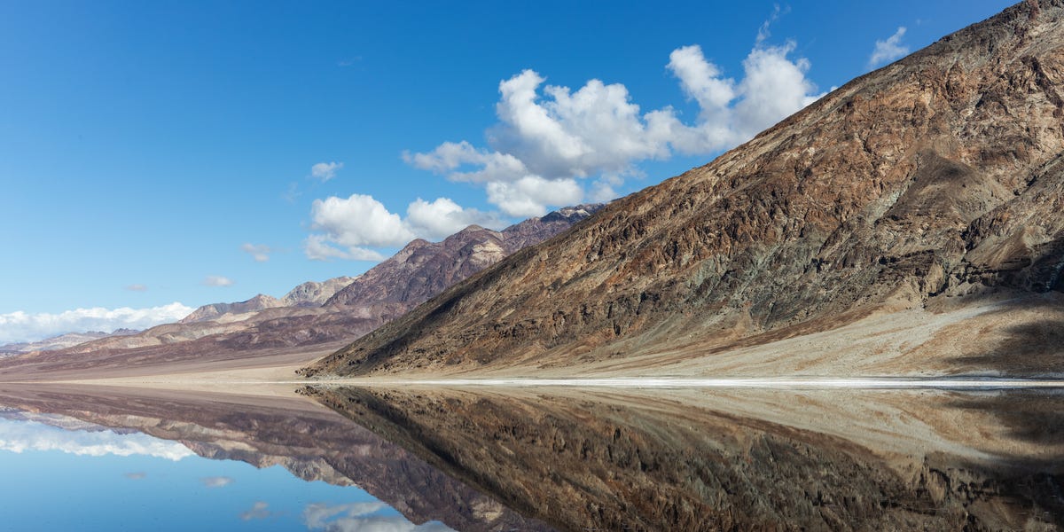
Death Valley is famous for behaving like an oven with excellent scenery. Water is usually the last thing visitors expect to find spreading across its salt-crusted floor. Yet after periods of unusually heavy rain, Badwater Basin has repeatedly transformed into a shallow, shimmering lakean echo of the enormous body of water that occupied the valley during the Ice Age.
This temporary lake is commonly called Lake Manly. Its recent appearances do not mean the ancient lake has returned permanently, nor is Death Valley preparing to become a beach resort. The water may be only inches deep and can disappear almost as dramatically as it arrives. Still, seeing a lake form at the lowest point in North America offers a spectacular lesson in geology, desert weather, and nature’s talent for ignoring expectations.
Lake Manly Returns to Badwater Basin
The latest widely documented return began after a remarkably wet fall in 2025. From September through November, Death Valley National Park recorded 2.41 inches of rain. November alone produced 1.76 inches, surpassing the previous November record of 1.70 inches set in 1923. Those numbers would sound modest in Seattle. In Death Valley, where average annual precipitation is roughly two inches, they qualify as a watery uprising.
Runoff collected in Badwater Basin, which sits 282 feet below sea level. The resulting Lake Manly was broad enough to create striking reflections but shallow enough that much of it would barely rise above a visitor’s shoes. Park officials described it as considerably smaller than the lake produced by the extraordinary storms of 2023 and 2024.
Why Water Naturally Collects Here
Badwater Basin is a closed depression surrounded by steep mountain ranges. Rain falling on the mountains rushes through canyons and across alluvial fans toward the valley floor. Once it reaches the basin, the water has no river carrying it to the ocean. Its main exits are evaporation and slow movement into soil and sediment.
The basin’s position explains why a small amount of regional rain can cover such a large area. Water spreads thinly across an extremely flat surface, creating a lake that looks substantial from a distance even when it is only ankle-deep. It is the hydrologic equivalent of pouring one glass of water onto a kitchen floor: not especially deep, but suddenly everyone is paying attention.
The Much Larger Lake That Once Filled Death Valley
Today’s temporary water is only a faint reenactment of prehistoric Lake Manly. During cooler, wetter periods of the Pleistocene, precipitation increased, evaporation decreased, and glaciers covered parts of the Sierra Nevada. Rivers and interconnected lakes carried water through the desert, allowing a vast lake to occupy much of Death Valley.
Geological evidence suggests that one major highstand occurred roughly 130,000 years ago. Ancient shoreline deposits found well above the modern valley floor indicate that the lake reached a maximum depth of approximately 115 meters, or about 377 feet, during that phase. Other reconstructions describe major Ice Age versions of Lake Manly approaching 100 miles in length.
How the Ancient Lake Disappeared
As the Ice Age climate changed, glaciers retreated and the region became hotter and drier. Less water entered the basin while evaporation intensified. Lake Manly contracted into smaller bodies of water, marshes, and isolated springs before the broad permanent lake vanished.
The water disappeared, but it did not leave quietly. Minerals carried into the closed basin remained after evaporation, accumulating over thousands of years. This process helped create the bright salt flats now associated with Badwater Basin and nearby formations such as Devil’s Golf Course.
Ancient shorelines remain visible on surrounding slopes, including the terraces etched across Shoreline Butte. Fossils, sediment layers, mineral deposits, and aquatic species living in isolated desert springs also preserve pieces of the lake’s history. Death Valley may look empty, but geologically speaking, the place has kept every receipt.
The Storms That Brought Lake Manly Back
Hurricane Hilary’s Historic Rainfall
The modern Lake Manly story accelerated on August 20, 2023, when remnants of Hurricane Hilary reached Death Valley. Furnace Creek received 2.2 inches of rain in one daymore than the park normally receives in an entire year. Some mountainous parts of the park likely received substantially more.
Water raced down steep, rocky slopes that could absorb little of the sudden rainfall. Flash floods tore across roads, moved boulders, deposited mud, damaged utilities, and forced the park to close for weeks. Every road in the enormous national park sustained some degree of damage. The same floods also delivered enough water to Badwater Basin to form an extensive temporary lake.
NASA satellite imagery documented the transformation from a pale salt flat into a dark body of water several miles across. The lake gradually shrank through the fall, but it did not disappear as quickly as many observers expected.
An Atmospheric River Refills the Basin
In early February 2024, an atmospheric river delivered another 1.5 inches of rain to the valley floor, while the surrounding mountains received even more. Across the six months following Hurricane Hilary, the valley floor accumulated approximately 4.9 inches of precipitation.
The new runoff enlarged Lake Manly until it measured about six miles long and three miles wide. Much of the water was around one foot deep, although depth varied across the irregular basin. For several weeks, conditions were sufficient for the National Park Service to permit kayaks and paddleboards.
The sight was gloriously absurd: paddlers floating across a place known for record heat, extreme aridity, and roadside warnings about dehydration. Snow-dusted mountains reflected in calm water while inflatable kayaks crossed the lowest point on the continent. Death Valley had briefly traded its frying-pan reputation for something resembling a natural infinity pool.
NASA Measured the Temporary Death Valley Lake From Space
Lake Manly was not merely a scenic curiosity. It also became a valuable scientific target for the Surface Water and Ocean Topography satellite, a joint mission led by NASA and France’s space agency.
Using satellite observations, researchers measured changes in Lake Manly’s surface elevation during February and March 2024. The analysis showed that the water’s depth declined from roughly three feet in some areas to less than half that amount over several weeks. These measurements demonstrated how satellite radar can track relatively small and shallow inland bodies of water, not just oceans and major lakes.
This capability has applications far beyond Death Valley. Accurate surface-water measurements can help scientists monitor reservoirs, wetlands, rivers, drought, and flooding around the world. Lake Manly essentially became a temporary outdoor laboratoryone with outstanding mountain views and absolutely no convenient boat ramp.
How an Entire Lake Moved Across the Desert
Lake Manly’s strangest trick arrived in March 2024. Strong winds pushed much of the shallow water approximately two miles north across Badwater Basin. Because the lake was so thin and spread across such a flat surface, sustained winds could redistribute it like water being blown across a giant tray.
The winds also accelerated evaporation and exposed broad mudflats. Visitors attempting to reach the retreating water dragged boats across wet sediment, leaving tracks and footprints that could remain visible for years. The National Park Service consequently prohibited boating on the shrinking lake to protect the fragile basin.
The episode revealed why “the lake is still there” does not necessarily mean conditions are suitable for recreation. A lake can be visible from a viewpoint while being too shallow, muddy, distant, or environmentally sensitive for paddling.
Is Lake Manly Really Reappearing More Often?
Temporary water has formed in Badwater Basin many times, so the phenomenon itself is not new. What has attracted attention is the sequence of dramatic appearances: major flooding in 2023, replenishment in 2024, and another shallow lake after record fall rainfall in 2025.
It would be misleading to attribute every individual storm or lake formation to a single cause. Tropical remnants, atmospheric rivers, seasonal weather patterns, regional ocean conditions, topography, and ordinary natural variability all influence precipitation in the Southwest.
Climate change adds another layer. A warmer atmosphere can hold more water vapor, which can contribute to heavier precipitation during favorable storm conditions. At the same time, rising temperatures increase evaporation and intensify heat. Death Valley may therefore experience a combination of harsher heat, longer dry periods, and occasional destructive rain events rather than a steady increase in useful water.
Lake Manly is not evidence that the desert is permanently becoming wetter. It is evidence that a famously dry landscape can be transformed by short, powerful bursts of precipitationand that averages rarely describe the full personality of an extreme environment.
What the Water Changes in Death Valley
Salt Flats and Sediment
Floodwater dissolves salt, shifts mud, and rearranges the delicate patterns on the basin floor. As the water evaporates, salt recrystallizes into new ridges and polygonal shapes. The familiar white landscape eventually returns, but it may not look exactly as it did before the flood.
Plants and Wildlife
Rain can activate seeds that have remained dormant in desert soil for years. Whether the result becomes a spectacular wildflower superbloom depends on additional factors, including temperature, timing, wind, and the survival of seedlings. Heavy rainfall is an important ingredient, but the desert refuses to provide guaranteed floral entertainment.
Death Valley’s aquatic history also survives in isolated populations of pupfish. These small fish are descendants of populations that lived in the ancient lake system before shrinking waters separated them into springs, creeks, and saline pools. Their existence is a biological reminder that Lake Manly was once an ecosystem, not simply a geological puddle with excellent public relations.
Can Visitors See Lake Manly?
Lake Manly is ephemeral, so photographs and reports can become outdated quickly. Water levels may change within days because of heat, wind, evaporation, and additional runoff. A broad reflective surface visible one week may become a distant strip of muddy water the next.
Visitors should consult current National Park Service alerts before traveling. Floods frequently damage roads, undercut shoulders, move debris, and close access routes. Badwater Road may be open in one direction while another section remains closed or requires additional caution.
Even when water is present, visitors should not assume that kayaking, paddleboarding, or walking across unconsolidated mud is allowed. Regulations can change as the lake retreats and sensitive areas become exposed. Staying on established or already-compacted routes helps prevent scars that may remain long after the water disappears.
Safety Still Matters in a Wet Death Valley
The presence of water does not make Death Valley’s climate gentle. Visitors should carry abundant drinking water, protect themselves from the sun, avoid entering flooded roads, and recognize that cell service is unreliable. Lake Manly is highly saline and muddy; it is not a source of safe drinking water.
Cooler months generally provide the best conditions for visiting low-elevation areas. Summer temperatures can become life-threatening, and walking across an open salt basin offers almost no shade. The lake may look refreshing, but Death Valley has not secretly installed air conditioning.
What Experiencing the Reappearing Lake Feels Like
Note: The following visitor experience is a descriptive reconstruction based on documented conditions and commonly reported observations. It is not presented as a claim of personal travel.
The experience begins before the lake becomes visible. Driving south from Furnace Creek, the road runs between pale alluvial fans and dark, folded mountains. Everything appears dry enough to crumble. The scale is deceptive: a feature that seems five minutes away may remain on the horizon for half an hour.
Then a thin line of brightness appears across the valley floor. At first, it resembles a heat shimmer. As the road descends, the line widens and begins reflecting the mountains. The brain takes a moment to accept the obvious conclusion: that is not glare. It is water.
At Badwater Basin, the famous elevation sign high on the mountainside marks sea level far above the parking area. Ordinarily, visitors step onto a firm salt path surrounded by rough, white polygons. During a Lake Manly event, the familiar trail may lead toward mud, damp salt, or shallow water instead.
The lake’s scale is easiest to appreciate from ground level. Its opposite shoreline can be difficult to identify because the water, salt, and sky merge into horizontal bands. Reflections double the Panamint Range, making the valley seem even larger. When the air is still, the surface becomes so smooth that clouds appear to have fallen into the basin.
Sound changes, too. Water softens the sharp visual severity of the salt flats. Small ripples make quiet tapping noises along the muddy edge. Footsteps squish instead of crunching. A breeze may push a skin of water across the basin while carrying the mineral smell of wet earth and salt.
During the deeper 2024 phase, paddlers described an almost surreal journey. Kayaks moved across water that was often barely deep enough to clear the bottom. There were no trees, docks, cabins, or ordinary lakeside landmarksonly open water, desert ranges, and snow on distant peaks. A person could paddle for several minutes and still feel as though the scenery had not moved.
The shallower 2025 version offered a different experience. The water was more suitable for viewing than boating, and reaching it could require a long walk from the parking area. That distance reinforced the lake’s temporary character. Its shoreline was not fixed. Wind and evaporation could redraw it while visitors watched.
Photography is most dramatic around sunrise or sunset, when low light turns the mountains gold, rose, or purple. Wide-angle compositions emphasize the enormous basin, while lower camera positions capture stronger reflections. Photographers must resist the temptation to march onto untouched mud for a perfect angle. A photograph lasts; unfortunately, so can a footprint in a fragile salt flat.
From Dante’s View, thousands of feet above Badwater Basin, Lake Manly looks less like a conventional lake and more like a silver brushstroke. That elevated perspective reveals how tightly the water occupies the lowest part of the valley. It also makes the ancient version easier to imagine. The modern pool is tiny compared with the Ice Age lake whose shorelines remain recorded on surrounding slopes.
The most memorable part of the visit may be its sense of borrowed time. Everyone knows the water is leaving. Sunlight, dry air, and wind are already dismantling the lake. The next visitor may find a smaller pool, a muddy plain, or the brilliant white salt surface restored.
That impermanence is the attraction. Lake Manly is not a new permanent destination with predictable seasons and rental equipment. It is a brief geological callbackan ancient landscape appearing in miniature before evaporation closes the curtain again.
Conclusion: Death Valley Is Never as Empty as It Looks
Lake Manly’s return demonstrates that Death Valley is not a static wasteland. It is an active basin shaped by faulting, floods, evaporation, salt, wind, and enormous climatic changes. The ancient lake disappeared as the Ice Age ended, but the valley retained the shape needed to collect water whenever rare storms deliver enough runoff.
The temporary lakes of 2023, 2024, and 2025 were dramatically smaller than prehistoric Lake Manly. Nevertheless, they allowed visitors and scientists to see the valley’s past briefly reflected in its present. Roads flooded, satellites measured changing depths, winds moved the lake, and paddlers crossed a place normally known for cracked salt and punishing heat.
Eventually, Lake Manly evaporates. The salt flats return, fresh mineral patterns emerge, and Death Valley resumes looking impossibly dry. But the basin has made its point: in the desert, vanished does not always mean gone forever.